East Sussex County Council (ESCC) have launched a new public consultation on their plans to make walking and cycling in and around Rye easier. The Local Cycling & Walking Infrastructure Plan aims to make walking and cycling more attractive, so more of us are encouraged to walk or cycle.
Their draft plan, ESCC say, focusses on areas of the county where there are the greatest opportunities to increase levels of cycling and walking, with an emphasis on delivering infrastructure improvements which will support those people who currently do not cycle or walk.

The proposed cycling and walking networks aim to connect people with the places they may often travel on everyday journeys, such as for school, work, and shopping and to promote walking and cycling for leisure and as a form of exercise. In addition, the strategy to get more of us walking and cycling will “improve our physical and mental health and wellbeing, help to reduce the number of people using vehicles, thereby reducing emissions from exhaust fumes and benefiting the environment.”
ESCC want to know if they have connected the right places and, if not, give you the opportunity to tell them and share your ideas. They would also like to know about any current cycling or walking trips that you may take, any barriers that you face in cycling and walking, and what measures you would like to see them deliver in the future.
A walking map would be useful
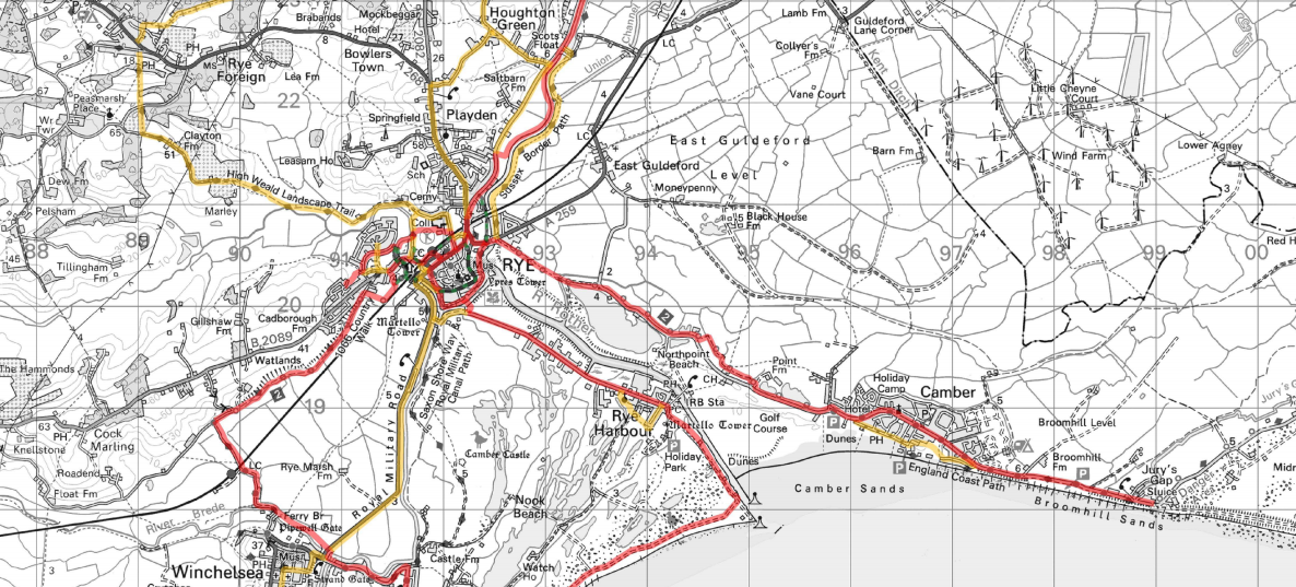
The proposed Walking & Cycling Plan includes detailed network maps that cover the whole of East Sussex, including a detailed map of proposed cycle friendly routes around Rye.
What the plan does not contain is a proposal to join up the long distance footpaths that converge on Rye, such as the 1066 Country Walk; High Weald Landscape Trail; Saxon Shore Way; Royal Military Canal Path and Sussex Border Path, as well as the other paths and rights of way in and around Rye. While their strategy gives a nod to encouraging more people to walk as a form of exercise the plan clarifies that “the scope of the work was limited to utility trips to work, education and shopping of up to 5km. It does
not include consideration of leisure trips outside the urban areas.”
Maps to encourage people to walk more have only been developed for Newhaven, Lewes, Eastbourne, Hailsham, Bexhill and Hastings.
Finally, the plan contains a list of infrastructure improvements that would need to happen to encourage more people to walk and cycle in and around Rye. One obvious omission is any improvements to the dangerous junction of the A259/Harbour Road that thwarted the England Coast Path coming through Rye.
New bridge remains uncertain
Instead, there is mention of a new bridge over the River Brede at Rock Channel. No further information has been given as to who will pay for the bridge, or when it will be built, but in a previous consultation ran by Natural England on the thwarted England Coast Path, they speculated that a property developer would cover the cost of the bridge.
It is Rye News’s understanding that the Hastings based property developer Martello Developments Ltd owns land either side of the River Brede.
You have until Friday, December 11 to make your comments and recommendations to ESCC. If you would like to see better signposting and paths to encourage walking and cycling in and around Rye, then submit your comments here.
Image Credits: Kevin McCarthy , ESCC Sustrans .


On behalf of the Rother Environment Group I have been involved with the development of this plan, through the Cycle East Sussex forum. It would be great if people could respond and were able to express their support for a comprehensive walking and cycling network around Rye and surrounding areas. However, I need to sound a note of caution which is that, as Kevin McCarthy points out, the plan “focusses on areas of the county where there are the greatest opportunities to increase levels of cycling and walking.” In terms of budgets (and therefore the chance of getting any infrastructure improvements in place), this means that ESCC is ONLY allocating funds to the larger towns (EG Eastbourne and Bexhill). There is no allocation whatsoever for Rye.
Can somebody explain to me how the current bus/ rail interchange would work under this scheme? The rural bus services are highly diagrammed to maximise the services for a limited budget. Two way traffic in the top end of Ferry Road with double decker buses looks to me to be all but impossible without demolition of buildings. A 15 minute delay in Rye with traffic gridlock would mean either a higher subsidy was needed or that services to outlying villages would be reduced.
The scheme would also seem to remove all/ reduce car parking at Rye station which in pre covid times was often full to capacity. This would hardly promote the use of public transport in a rural area with limited bus services.
The Rye Neighbourhood Plan set some policy for improved cycle connectivity across Rye (Page 59), which chimes with this ESCC report We saw a distinct need to connect the cycle routes , which converge on Rye by safe routes across the Town. Citizens should press for such improvements which will not only benefit citizens but be attractive for visitors.
Anthony Kimber PhD
For Rye Neighbourhood Plan Steering Group
Thank you for this encouraging news. Part of the proposed footpath/cycle route along the River Rother was accessible as a footpath until last year when a supposed landowner put up barbed wire and a no trespassing sign (this is a few hundred metres north of the tennis courts and just over the border with Playden). It was a path I had walked on since 2013 but the ‘owner’ insisted it was her land. A neighbour had discovered an OS map from the late 1940s that showed the land on the Rye side of the Rother as being a public farm track running from the tennis courts to the Scots Float sluice. We sent it to ESCC 18 or so months ago and your article has brought such welcome news as ESCC appears to recognise the flood defense path as a public path. Will definitely support the consultation and let other know about it.
Talking about footpaths, we must make sure the stile and signs are put back in front of Castle cottages in between the River Brede, many walkers unfamiliar with the area,are unsure whether to open the 5 bar gate and proceed along it,thinking its private property, coming from the other side many people cannot see the other gate, due to overgrown trees and vegetation, this needs to be addressed, before that path is lost for ever.
Paths around Rye are poorly maintained so I am pleased to see the path to Rye Harbour
Grayhams Way has had the over hanging trees cut back giving another metre in width
Derek Bayntun